Chagos Archipelago Map for UPSC CSE
This page contains the map of Chagos Archipelago which is in news for some important geopolitical developments alongside important notes on the developments.
Agreement Between U.K. and Mauritius
- The U.K. and Mauritius have agreed on the return of the Chagos Archipelago to Mauritian sovereignty.
- This resolves a long-standing dispute, including the strategic Diego Garcia base.
- The return is seen as completing Mauritius’ decolonization process.
Chagos Dispute Background
- Colonial Background:
- Britain claimed the Chagos Archipelago along with Mauritius in 1814.
- In 1965, before Mauritius gained independence (1968), the U.K. separated the islands to create the British Indian Ocean Territory (BIOT).
- Military Leasing:
- In 1966, Britain leased Diego Garcia (the largest island) to the U.S. for a military base.
- Native Chagossians were displaced.
- Legal Disputes:
- Chagossians have fought legal battles for the right to return.
- Mauritius has claimed sovereignty over the islands since 1968.
- International Rulings:
- In 2019, the International Court of Justice (ICJ) ruled that the U.K. must return the Chagos Islands to Mauritius.
- The U.K.'s administration of the islands was deemed unlawful by the ICJ.
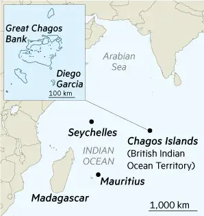
Geographical Location of Chagos Archipelago
- Location: Central Indian Ocean, about 1,600 km south of India’s southern tip.
- Key Islands: Includes atolls like Diego Garcia, Peros Banhos, and Danger Island.
- Climate: Tropical marine climate, moderated by trade winds.
- Disputed Nations: U.K. (current administrator) and Mauritius (claimant), with U.S. involvement due to the military base on Diego Garcia.