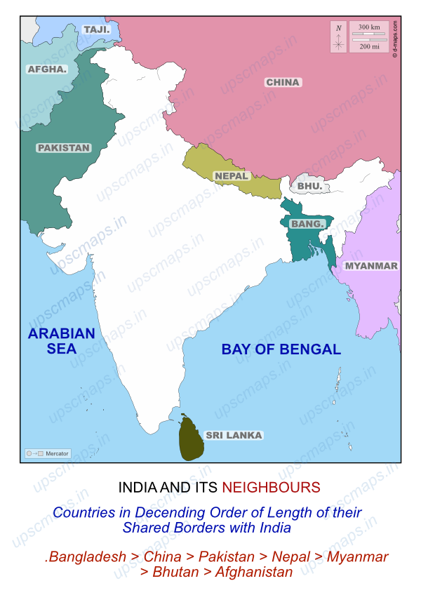
India and Its Neighbours Map for UPSC CSE
This page contains the map of India and its neighbours which is in news. We have added important notes on it as well.

India, located in South Asia, shares land and maritime borders with several countries. It is bordered by seven countries on land and two island nations through maritime boundaries. These neighbours have significant political, cultural, and economic ties with India.
In order of the length of border shared by India and its neighbours, the neighbours are:
Bangladesh > China > Pakistan > Nepal > Myanmar > Bhutan > Afghanistan
Land Neighbours of India
India shares land borders with the following seven countries:
-
Bangladesh:
- Border Length: 4,096.7 km (longest border)
- Capital: Dhaka
- Bordering Indian States/UTs: West Bengal, Assam, Meghalaya, Tripura, Mizoram
- Important Border Line: Radcliffe Line
-
China:
- Border Length: 3,488 km
- Capital: Beijing
- Bordering Indian States/UTs: Ladakh, Himachal Pradesh, Uttarakhand, Sikkim, Arunachal Pradesh
- Important Border Line: McMahon Line (in the northeastern region)
-
Pakistan:
- Border Length: 3,323 km
- Capital: Islamabad
- Bordering Indian States/UTs: Gujarat, Rajasthan, Punjab, Jammu & Kashmir, Ladakh
- Important Border Line: Radcliffe Line (India-Pakistan boundary), Line of Control (LoC)
-
Nepal:
- Border Length: 1,751 km
- Capital: Kathmandu
- Bordering Indian States: Uttarakhand, Uttar Pradesh, Bihar, West Bengal, Sikkim
-
Myanmar:
- Border Length: 1,643 km
- Capital: Naypyidaw
- Bordering Indian States: Mizoram, Manipur, Nagaland, Arunachal Pradesh
-
Bhutan:
- Border Length: 699 km
- Capital: Thimphu
- Bordering Indian States: Sikkim, West Bengal, Assam, Arunachal Pradesh
-
Afghanistan:
- Border Length: 106 km (shortest border)
- Capital: Kabul
- Bordering Indian States/UTs: Ladakh
- Important Border Line: Durand Line
Island Neighbours of India
India shares maritime borders with two island nations:
-
Sri Lanka:
- Capital: Sri Jayawardenepura Kotte (Legislative), Colombo (Executive)
- Separation: Palk Strait and Gulf of Mannar separate Sri Lanka from India’s mainland.
-
Maldives:
- Capital: Male
- Separation: The Eight Degree Channel separates the Maldives from India’s Lakshadweep islands.
Key Points about India’s Borders
- Total International Land Boundary: 15,106.7 km
- India has the fifth-longest land boundary with Bangladesh in the world.
- The Indian state of West Bengal shares the longest international border with neighbouring countries, while Nagaland shares the shortest.
- Ladakh, Sikkim, and Arunachal Pradesh each share borders with three different countries.
Important Border Lines
- India-Pakistan: Radcliffe Line
- India-Bangladesh: Radcliffe Line
- India-China: McMahon Line (in the northeastern region)
- India-Afghanistan: Durand Line
De Facto Borders
- Line of Control (LoC): Separates Indian and Pakistani controlled parts of Jammu & Kashmir and Ladakh. It is not a legally recognized international boundary but functions as the de facto border since the Karachi Agreement of 1949.
- Line of Actual Control (LAC): Separates Indian and Chinese controlled territories and acts as the de facto border between India and China.
Border Guarding Forces
- India-Nepal: Sashastra Seema Bal (SSB)
- India-Bhutan: Sashastra Seema Bal (SSB)
- India-Pakistan: Border Security Force (BSF)
- India-Bangladesh: Border Security Force (BSF)
- India-Myanmar: Assam Rifles (AR)
- India-China: Indo-Tibetan Border Police (ITBP)
Key Facts for UPSC Aspirants
- Nepal, Bangladesh, China, and Pakistan share land boundaries with five Indian states each.
- Ladakh shares borders with China, Pakistan, and Afghanistan.
- Sikkim shares borders with Nepal, China, and Bhutan.
- Arunachal Pradesh shares borders with Bhutan, China, and Myanmar.